Garmin Pilot app for iPhone and iPad
4.6 (
7536 ratings )
Weather
Navigation
Developer:
Garmin DCI
Free
Current version:
9.1.5, last update: 6 years ago
First release : 22 Dec 2009
App size: 219.67 Mb
*30 Days Free Trial on initial download!*
Plan. File. Fly. Log.
Garmin Pilot is the most comprehensive suite of tools for the iPad designed specifically for general aviation and corporate pilots. Flight planning, charts, interactive maps, weather briefing resources and navigation capabilities; it’s all included. The app’s intuitive interface mirrors those on the newest Garmin touchscreen avionics so you can go seamlessly from preflight to inflight.
Plan
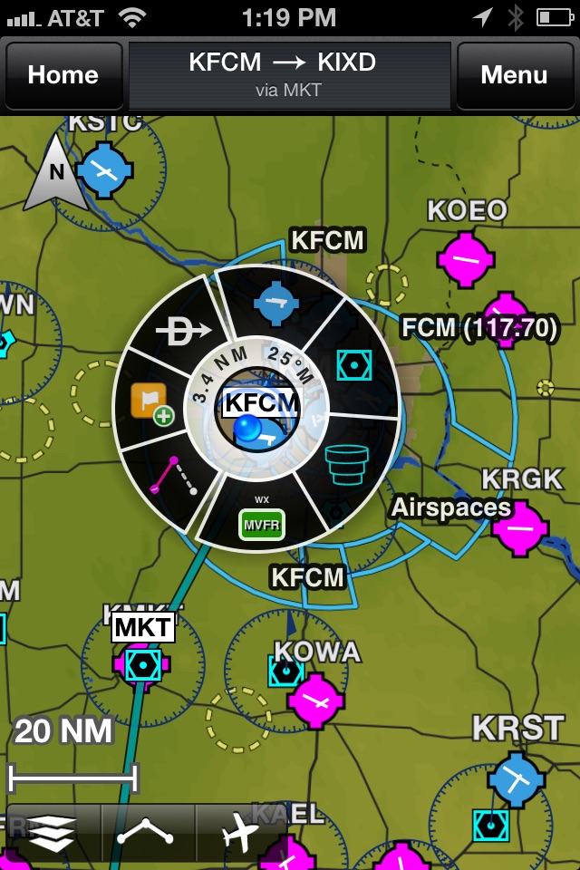
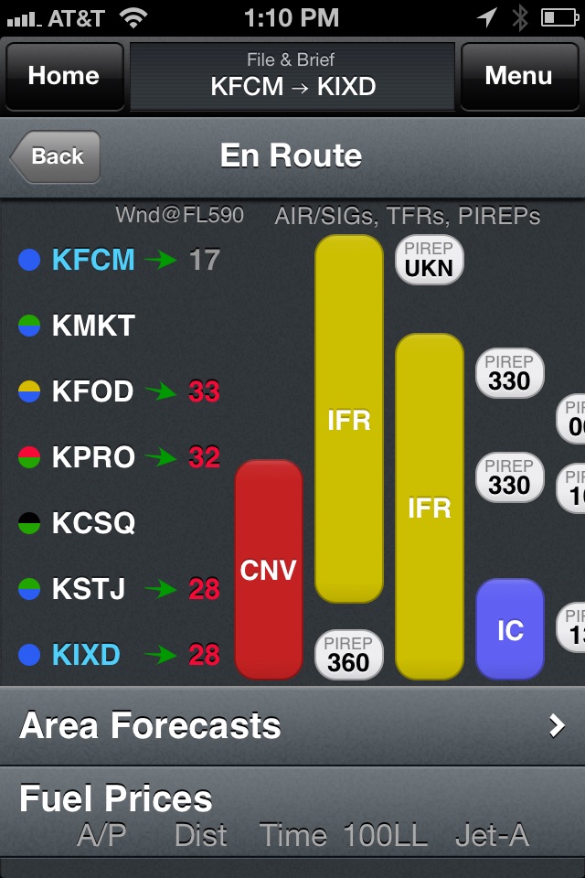
Garmin Pilot’s powerful capabilities start with pre-flight planning, providing pilots with the most comprehensive aviation weather information to make better-informed flight decisions. Pilots can check NEXRAD radar, visible and infrared cloud imagery, METARs, TAFs, AIRMETs, SIGMETs, PIREPs, NOTAMs, winds and temperature aloft, TFRs and lightning data. With Garmin Pilot, data can be displayed over Garmin’s interactive maps that support track-up navigation, VFR sectional or an IFR low or high en-route chart to visualize the weather for your route. Add text-based weather widgets and use the exclusive NavTrack feature to view weather along the planned route.
File
With Garmin Pilot, users can easily enter a flight plan and interactively edit it on the map. Pre-loaded forms make it quick to save and reuse data for frequently flown routes. And when the flight plan is ready, Garmin Pilot makes it simple to file, amend or close the flight plan via Leidos Flight Service or DUATS.
Fly
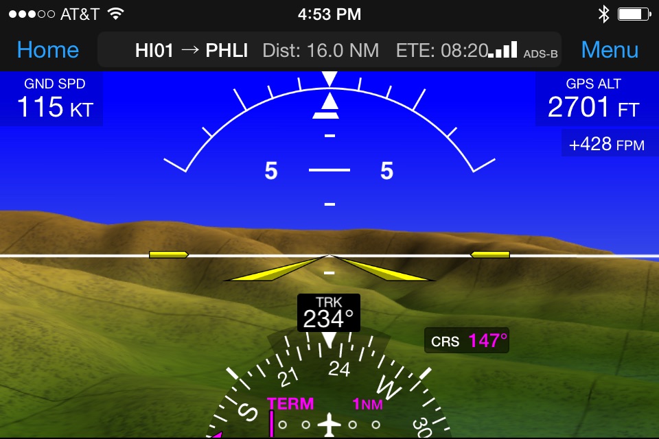
Garmin Pilot provides full en-route navigation capability on its moving map. Pilots can also navigate with Garmin’s patented panel, a GPS-driven instrument pack with a graphical HSI directional display and indicators for groundspeed, altitude and vertical speed. After takeoff, pilots can continue to view real-time weather in the U.S. and traffic information by wirelessly connecting to Garmin’s GDL 39 3D portable ADS-B Receiver (sold separately).
Log
Garmin Pilot includes a comprehensive electronic logbook that syncs with flyGarmin. The logbook automatically generates entries based upon GPS data collected during the flight, tracks currency, supports manual entries, endorsements and creates reports.
Garmin Pilot U.S. Standard:
- Rich, interactive maps support Track-Up navigation
- Charts: VFR Sectionals, low and high IFR en-route, airport diagrams and approach procedures
- Ability to view Jeppesen Terminal Charts (Jeppesen echart subscription required)
- Weather Maps: Animated radar, Infrared and Visible Satellite, AIRMETs, SIGMETs, Lightning, TFRs and more!
- Extensive text products: METARs, TAFs, Winds Aloft, PIREPs, AIRMETs, SIGMETs, Area Forecasts and NOTAMs
- AOPA Airport Directory
- Weight and Balance
- Checklists
- Flight plan filing via Leidos Flight Services
- Garmin patented navigation panel
- Terrain and Obstacles
- Smart Airspace
- Fast Find predictive Waypoint Entry
- Logbook
- Optional VFR Premium: Synthetic Vision (SVX), Terrain and obstacle alerting, and Garmin SafeTaxi®
- Optional IFR Premium: VFR Premium plus geo-referenced Garmin FliteCharts®
Garmin Pilot has regional offerings for Africa, Asia, Australia, Canada, Europe and Latin America. Features include:
- Worldwide Jeppesen NavData
- Rich, interactive maps support Track-Up navigation
- Radar and Satellite imagery for Western Europe, U.S., Canada and Australia
- Ability to view Jeppesen Terminal Charts (Jeppesen echart subscription required)
- Worldwide METARs, TAFs, AIRMETs, SIGMETs, NOTAMs and winds aloft
- VFR Flight Plan Filing
- IFR autorouting and Flight plan filing in Europe
- Terrain and Obstacles with alerting
- Synthetic Vision (SVX)
- Smart Airspace
- Logbook
- Optional VFR charts from DFS, IGN and NATS and IFR enroute charts from EuroControl
- Optional Garmin FliteCharts® and SafeTaxi® diagrams available on a country-by-country basis
*Note: Use of GPS running in the background may decrease battery life.*
*Note: One subscription to Garmin Pilot may be used on three devices.*
Pros and cons of Garmin Pilot app for iPhone and iPad
Garmin Pilot app good for
Version 7.3 og 2015-05-01 brings Nav Canada VFR Navigation Charts (VNC) and VFR Terminal Charts (VTA) along with IFR Low and High enroute charts. This THE major improvement that Canadians have been waiting for years... thank you Garmin
Im a storm spotter, not a pilot, but this app has the best satellite imagery, international radar data, global lightning data, and other useful stuff.
Has location labels on top of weather data unlike most other apps which is very useful. Just wish borders were also on top.
A very good app. The only problem is that you do not support any third party ADS-B in receivers. You only support your own product. That is a real shame and that is the reason why I did not renew my subscription. If you start to support third party ADS-B receivers, I would re-subscribe.
This is a nice app to use in the cockpit. It is a big help where it has the NEXRAD on the IFR enroute charts. It is really good because I use the GNS 530 to fly with. This is much better than my GNS! This app needs some improving...
- ADS-B Traffic Alerts visually and voice announces "Traffic, Traffic".
- Split screen for two Approach plates. Example, STAR split with A/P diagram or Approach plate with A/P diagram. Also split screen on synthetic vision.
- Active legs appear magenta and has "approaching waypoint" indicator like GNS 530 so pilot knows when to change course
- SafeTaxi easier to find and more availability (my local airport doesnt have it available)
- Improve the METAR weather page. It says "No Wx" and many airports I go to has an AWOS and publishes a METAR.
- Lower Price!
- Make HSI have selectable HDG... For example, Direct a VOR and you can change heading to make needle center.
- Needs a "Procedure" button like the GNS 530. I want to load an instrument approach for situational awareness
- Approach plate on map page overlay.
- Would be nice if Geo-Ref could be available on the actual airport diagram.
- Vertical Speed indicator user changeable from 2,000 FPM to 6,000 FPM
- Needs Runway Proximity Advisor™: The Runway Proximity Advisor is a visual and audio alerting feature – designed to help reduce runway incursions – that advises you when it predicts your aircraft is approaching, entering, or crossing a runway... Just like ForeFlight
- Needs holding patterns and pattern entry similar ForeFlight
- Needs reminder messages programmable at certain times
- Checklist
- Better integration with 1-800-WX-BRIEF to file a flight plan electronically.
- Needs a small circle similar to a G/S that has a descent profile loaded to get a proper descent angle to get to desired altitude.
Other than this, Garmin Pilot is my choice for the cockpit.
Need I say more?
Also love the glide range ring, though I hope to never need it.
It would have been nice if Flying ace 2, the previous reviewer, had upgraded to the most recent version of Garmin Pilot and actually knew something about the program before writing his quite off-the-mark review.
Garmin Pilot, in its most recent versions which were released BEFORE the date of his review, fully supports overlaying the approach chart right over the moving map display together with all of the weather and traffic overlays available if you have an ADS-B equipped airplane. It also supports the use of Jeppesen charts which is really only of use to IFR pilots.
Finally, it is certainly possible to have multiple windows on the screen. Right now, I have the moving map with weather, traffic and the Jeppesen approach plate on the left screen and, at the same time, an AHRS driven, HSI based panel on the right. These features have been part of Garmin Pilot since before the date of Flying ace 2s review.
Garmin Pilot is a fabulous program with a graphics engine superior to ForeFlight at the moment. Garmin came out with a data-driven map display long before ForeFlights newest release and it is still graphically superior. I expect ForeFlight to catch up soon. Thats why I use both in my IFR flying and keep them updated to their respective latest versions.
Some bad moments
When we already pay a lot of money to keep our Garmin equipment up to date (GTN units) every year, we should at least have discounts to update and use this app.
And, only then we might consider buying the equipment to connect an aircraft GTN system to our iPad.
We are not airline companies, we are pilots.
Good night sir. Do you plan to include Brazils airspace in future versions? Grateful. Romeo
While beeing a foreflight user, i was more then happy to see garmin finally moving forward and provining charts for europe, the us and beyond!
Night vision and vfr/ifr mapview is great, you get a clear airspace picture. Even if you register the us base version, you get a worldwide fixes database! The synthetic 3d vision is working great. Syncing with D2 watch finally works (ipad >v2 required). The aspects above are not provided or less well done imho by foreflight to date.
However there are some annoyances and as a pilot u feel garmin is not willing to provide a too powerfull app, maybe to protect its hardware aviation products. Some evidence:
- its not possible to simply paste a copied flight path into the garmin fligh plan, each fix needs to be entered manually
-battery life of the g39 3d ads-b wx gps is half of what foreflights stratus2 offers and not sufficient for long xcountry flights
Garmin Pilot is a good app - however foreflight is not as protective (and syncs with flightsims, so you can train handling and procedures on the ground). For us/canadian pilots i would still recommend foreflight over Garmin Pilot. For all others i recommend to check your requirements before buying.
Final hint: Get this garmin app from the us istore, the german store charges much higher!
Plates are not up to date as valid period has expired even though they saw this is how they do it.
No VNC or WAC charts for Canada
This is not a Flight Bag as no current charts and expired plates.
Not worth the price
Good, I guess for fixed wing. Unacceptable for VFR rotary wing.
Cant connect my D2 Bravo to the app and as a result cant create flight plans. Without the Garmin Pilot app connection watches seems to be useless. 5 stars only after D2 Bravo support!!!
Usually Garmin Pilot iOS app used & searched for
garmin,
garmin app,
garmin mobile,
ads-b,
garmin pilot,
garmin weather,
garmin navigation,
aviation weather,
garmin dci,
lilot,
and other. So, download free Garmin Pilot .ipa to run this nice iOS application on iPhone and iPad.